

Idaho remains stubbornly incomprehensible, all things to all people. In geography books and in popular literature, Idaho is potatoes, silver mining, and Sun Valley. It’s one of the states that kids are most likely to stumble on in their geography bees. Its capital, Boise, is impossibly unmemorable because to a third-grade mind the name, a derivative of bois (“woods” in French), seems to be a mental dead end in a way that “Austin” or “Olympia” or “Tallahassee” are not. “All Boise names,” writes Lalia Boone, “are transferred from the name given the river by French Canadian explorers and trappers for the great variety of trees growing along its banks. After traveling over many miles of arid land, they are said to have exclaimed, ‘Les bois, les bois! Voyes les bois.’ ” What school child would know, or, knowing, care about an etymology as happenstance as that?
The state seems to have confused even the federal government. “For many years,” writes Leonard J. Arrington, in his massive History of Idaho, “the United States could not make up its mind about this large inland area.” In a way, that’s still true. Even on a map, the state looks odd. Its shape is illogical, way too thin at the top and disproportionately fat at the bottom. It looks as if it’s missing some pieces or ought all to belong to something else. And in fact the land that now comprises Idaho did once all belong to something else. “It was included,” says Arrington, “in the British Northwest until 1820, when it became part of the Oregon Country. In 1848 it was recognized as a piece of Oregon Territory, and in 1853 the northern half was inserted in newly created Washington Territory. When Oregon became a state in 1859, the entire area and parts of western Wyoming and Montana were absorbed in Washington Territory. But in 1863, when the difficulties of transportation made it impossible to govern the region from Olympia, Idaho was declared a separate territory that included all of present-day Montana and nearly all of present-day Wyoming. Not until 1868 did Idaho Territory emerge with its present state boundaries.”
Look for stability and you find none. Over the course of eons the state’s undergone changes in topography from mountain top to ocean floor, and its climate has varied from the vulcanism of the Eocene period to the successive glaciations of the Ice Age. In between fire and ice, for a few million years, Idaho was tropical. And before its climate was tropical it was literally coastal. For something like 700 million years, from the end of PreCambrian time until about the middle of the Cretaceous period 100 million years ago, the western edge of Idaho was the coast. Westward from Idaho’s shores 800 million years ago there stretched the open ocean. Except for the miracle of plate tectonics, Boise might be beachfront.
But nothing is less secure than the earth we stand on, and for hundreds of millions of years during the late Paleozoic and Mesozoic eras, the lithospheric plates that carried the floor of the Pacific Ocean and the entire North American continent drifted together. In time the floor and the continent collided—if an engagement that occurs at the speed of two inches a year can be called a collision. Every year brought land masses in the Pacific closer to the coastline. They came nearer by a mile or so every 32,000 years, hurtling towards each other pell-mell, geologically speaking, until eventually West mashed East with a momentum of a quadrillion tons. It must have been a hell of a sight for whatever eyes were around to see it when the islands that are now the Okanogan Highlands docked in or around what was to become the city of Lewiston.
That collision and others like it raised the Rocky Mountains, so that the state of Idaho now lies between those prodigious mountains and the Pacific Ocean. It’s the first land you reach after struggling across the continental divide. You might think that over the normal course of events the Americans spilling westward over the mountains would have followed the established pattern of frontier settlement, filling the country up from east to west, so that they would homestead first in Idaho, then in Washington, Oregon, and California. Not so: Idaho has the curious distinction of being the last of the contiguous American states to be visited by American explorers. Even though several states were more remote, Idaho was for some reason the last place the early discoverers got to see. Not until August 12, 1805, when Meriwether Lewis looked down and west from the continental divide at the summit of Lemhi Pass, was the land that was to become Idaho seen by Euro-American eyes. Lewis seems not to have been particularly impressed. His journal records his discovery of “immense ranges of high mountains still to the west of us with their tops partially covered in snow”—at that point, what else was new?—and, after reconnoitering the western slopes of the divide for about three fourths of a mile, he turned around and went back. He and Clark subsequently crossed and recrossed Idaho on their way to and from the Pacific.
Lewis and Clark’s encounter with Idaho provided the type for a good part of the rest of the century of Western settlement. Idaho was the place you went through on your way someplace else. Your only ambition was to get through or over it. Between 1830 and 1850 thousands of white settlers traversed the southern part of the state on their way to Oregon and California, but only those who had the misfortune to die in Idaho stayed there. Except for the Jesuit mission a few miles west of Coeur d’Alene, the trading posts, Fort Hall and Fort Boise, and “a mountain man or two,” writes Arrington, “no white settlers lived in Idaho for any length of time until 1855.” In contrast to much of the rest of the West, which underwent extensive settlement and “development” in the middle decades of the nineteenth century, Idaho retained its aboriginal cultures as the only real populations. Not until the discovery of gold during the 1860s did permanent settlers arrive in Idaho in significant numbers, and it was only because of the developing market for northwest timber at the end of the century, when supplies from the great midwestern forests had begun to dwindle, that Idaho was considered a likely place to homestead.
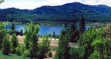
That history got a late start in Idaho turned out to be an unexpected piece of personal good fortune. What in most other places in the world counts as “history” still lies in Idaho in living memories. When Nancy and I moved to Alder Creek in 1972, we moved to one of the last regions of the United States where it was possible to talk to some of the men and women who had homesteaded it. The St. Maries telephone directory was so small you could comfortably fit it, folded, no less, into your hip pocket. And most of the names in that directory were the family names of the first Europeans to settle in that part of the country not quite a century ago. Little has changed since then. Even now you can still talk to a handful of those first settlers. Among my friends then were some of those people, people who were alive in the first decade of the twentieth century, some of the first Europeans to walk Idaho land, breathe Idaho air, piss in Idaho snow.
Sometimes in the summer I drive the gravel roads to what is left of the houses of the people I knew and pull to the side and sit for a while on the hood of the truck. Solitude and open spaces may be what we think we seek, but it is social life that nourishes us, helps us grow. “Contemplation of nature alone,” says Henry Walter Bates, “is not sufficient to fill the human heart and mind.” Nearly all of the people who were my friends and neighbors in the years I lived in Alder Creek are dead now or moved away, but it is because of them that the seven years I lived in Idaho were half magical and yet more real than anything else I have ever seen or done.
• • •
“On All Sides Nowhere,” from On All Sides Nowhere: Building a Life in Rural Idaho by William Gruber. Copyright (c) 2002 by William Gruber. Reproduced by permission of Houghton Mifflin Company. All rights reserved.